It has been cold, wet, foggy and down right depressing here in the southern San Joaquin Valley the last couple of weeks. This is fog season and we can go for weeks without seeing the sun. So, this past week-end my buddy Jim and I took off for an over nighter through Death Valley with Beatty Nevada as our final destination. Beatty is 35 miles south east of Scotty's Junction.
Click on map to enlarge.
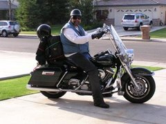
 Here we are packed and ready to roll.
 We left Bakersfield heading east on Highway 178 through the Kern Canyon up to Lake Isabella. We stopped at the "Dam Corner Cafe" which is located just below the dam that holds back the waters of Lake Isabella and had breakfast.
 After breakfast we saddled up and continued east on Highway 178 until we hit Highway 14. Riding north on Highway 14 we soon merged with Highway 395 ending up in Lone Pine. After gassing up in Lone Pine we traveled east into Death Valley.
 Stopping at "Stovepipe Wells Village" we ran into this group of riders who were also from Bakersfield.
Click on map to enlarge.
 Here we are packed and ready to roll.
 We left Bakersfield heading east on Highway 178 through the Kern Canyon up to Lake Isabella. We stopped at the "Dam Corner Cafe" which is located just below the dam that holds back the waters of Lake Isabella and had breakfast.
 After breakfast we saddled up and continued east on Highway 178 until we hit Highway 14. Riding north on Highway 14 we soon merged with Highway 395 ending up in Lone Pine. After gassing up in Lone Pine we traveled east into Death Valley.
 Stopping at "Stovepipe Wells Village" we ran into this group of riders who were also from Bakersfield.
When Bob Eichbaum envisioned a resort in Death Valley he could never have imagined that one day a million people a year would visit the park. Stovepipe Wells Village, a modest oasis named for a historic site located a few miles to the northeast. There, long ago, an old stovepipe was sunk into the sand to form the shaft for a much used well. Stovepaipe Wells is at sea level and just east of here a few miles the elevation drops to 232' below sea level. The lowest point in Death Valley is Bad Water at 282' below sea level making it the lowest point in the United States. Just 76 miles to the west is Mount Whitney which is the highest point in the continental United States standing at 14,505'
 Panamint mountain range in the background.
 We arrived at Beatty around 3 in the afternoon, finding this hotel, reserving a room then cleaning up for an evening in the casino...
 After a few hours in the casino and having no luck what so ever we turned in for the night. Sunday morning we headed north out of town, after a few miles we came across this site...it was closed.
 This plane was there...I would like to know the story behind it?
 About 60 miles north of Beatty is "Scotty's Castle" named after "Death Valley Scotty". He told everyone that he built this castle in northern Death Valley with money from his "secret" gold mine. That was not quite the truth. A Chicago millionaire and his wife built their "Death Valley Ranch" in the cool of Grapevine Canyon and they let their friend Scotty live there as a guest.
 Hidden in the green oasis of Grapevine Canyon in far northern Death Valley, the Death Valley Ranch, or Scotty's Castle as it is more commonly known, is a window into the life and times of the Roaring 20's and Depression 30's. It was and is an engineer's dream home, a wealthy matron's vacation home and a man-of-mystery's hideout and getaway. Walter Scott, Death Valley Scotty, convinced everyone that he had built the castle with money from his rich secret mines in the area. Albert Mussey Johnson actually built the house as a vacation getaway for himself and his wife Bessie. Scotty was the mystery, the cowboy, and the entertainer, but he was also a friend. Albert was the brains and the money. Two men as different as night and day, from different worlds and with different visions - who shared a dream.
 Here you can see the "Castle" on the left, the guest house is on the right and in the background is the clock tower.
 This is a generator that is powered by water. The valve you see in the front controls water flow into the volute which turns a generator that is coupled to it. Direct current is sent from the generator to a bank of 12 volt batteries which are used for lighting.
 There are many tunnels under the castle. The tunnels were used for all plumbing and electrical. Services like food, laundry and maids also used the tunnels. The tile you see in the photo below was purchased and shipped in from Spain for the pool which was never completed.
 After going through two different tours of the castle and guest house we headed south to the "Ubehebe Crater". The crater is a large volcanic crater 600 feet deep and half a mile across. This crater was created by steam and gas explosions when hot magma rising up from the depths reached ground water. The intense heat flashed the water into steam which expanded until the pressure was released as a tremendous explosion.
 After taking in the sights around the crater we made a bee line back to the cold, wet, foggy and down right depressing San Joaquin Valley... and that ends another Lumpy Adventure!
Note: I found the following information on the plane at the National Transportation Safety Board web site.

1 comment:
That group from Bakersfield are some of the Saturday morning regulars at BHD!
Buzz
Post a Comment